


 : Kari Medig | Lyon's Bluff
Six Easy Hikes With Giant Views
In Nelson and Kootenay Lake, we’re lucky that some of our best views are easy to get to—and by foot. No gondola necessary, no lift ticket, no hours of hoofing it from the valley bottom to the very tops of mountains. If you’re here with a family, low on time, looking for a quick burn, or hiking’s not your usual thing but you still appreciate a sprawling vista, we got you. Here are our favourite easy routes to the most visually arresting landscapes.
Pulpit Rock
This is the most popular hike in Nelson, and for good reason. First, it’s basically right in town: Cross BOB (the big orange bridge) over to the North Shore and find the trailhead on Johnstone Road. There's even a bucket of loaner trekking poles and a donation bin at the trailhead—the century-old trail is maintained by volunteers. You’ll find a good amount of parking but it’s close enough you could cycle if you want (there’s a bike rack), or if you’re a runner it’s not outrageous to get to by foot.
The 3.6 km (2.2 mi) roundtrip winds up moderate switchbacks on a well-groomed trail, through hillside pines, to land on a bluff high above Nelson. From here you can spy the west arm of Kootenay Lake with boats swirling about, and get a full view of the Queen City of Kootenays. It takes 30 to 60 minutes up, and a little bit less to come back down.
Season: mid-April to late October
Lyon's Bluff
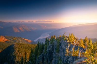
The ying to Pulpit Rock’s yang, this quieter 3.4 km (2.1 mi) trail starts a little farther north from the big orange bridge, right off highway 3A. It is built and maintained by the same society that takes care of the Pulpit Rock trail, and serves as a quieter alternative. This one goes through open forest so it’s a little hotter on warm days, but also frees up from snow earlier in the season.
The more recently built route is a steady ascent with stepping stones carefully embedded—in some ways a rustic staircase to the skyline. Same as Pulpit, it reaches a wide bluff opening views over the lake, town and the bridge below.
Season: mid-April to late October
Mount Buchanan
Looming high above the town of Kaslo, Mount Buchanan served as a fire lookout from 1965 to 1982, and you can still visit its historic fire tower today. Head to the Blueridge Forest Service Road and follow signs to the summit. The lookout sits at 1,912 m (6,272 ft) with unencumbered views over Kootenay Lake, Kokanee Glacier Provincial Park, Goat Range Provincial Park and the Purcells. The 360-degree panorama encompasses two entire mountain ranges and the main waterway below. You can walk a 2 km (1.24 mi) loop with interpretive displays and vivid wildflowers once they’re in season (mid-July) to get different vantage points.
There's a wheelchair-accessible toilet, picnic tables and signs identifying local peaks, glaciers and drainages. The top of Mount Buchannan also serves a hang-gliding take-off point, so watch out for the steep banks below the launch ramps. Mountain bikers arriving at the summit will have pedalled the Friendly Giant trail—an 18 km (11.8 mi) climb from valley bottom!
Season: mid- to late June to late September
Pilot Bay Lighthouse
The East Shore of Kootenay Lake is a special place in its own rite. Depending on which direction you’re coming from, the world’s longest free scenic ferry starts out the journey with a cruise across the lake. From the ferry landing, turn south on Pilot Bay Road and drive a few minutes until you see signs for the lighthouse.
It’s a 0.6 km (0.4 mi) out-and-back on a short but steep path to the historic lighthouse, which dates to the sternwheeler era when steam vessels moved goods and prospectors between mining communities. From the viewpoint you can see all three arms of Kootenay Lake; the lighthouse is open and visitors can climb to the lantern room gallery at the top
Those who want a bit more can wander the shoreline on the Pilot Peninsula trail another 3.5 km (2.1 mi), to Boomer’s Landing, a secluded pebble beach extending the walking from 30 minutes to three hours or so.
Season: late March to December
Ross Lake
A deeper escape near Balfour, Ross Lake requires a bit of offroad driving but rewards with a placid subalpine lake and campsite that you can spend hours or even the night at. From Highway 3A, take Beggs Road to the Red Fish Forest Service Road and then follow the signs.
The trail to the lake is 3.5 km (2.2mi) return and climbs 298 metres (978 feet) to still blue water, reflecting the surrounding trees and peaks in gentle terrain. Faint boot paths circle the lake, guarded by rolling ridge lines. It’s an excellent payoff: for a reasonably small effort, you get the feeling of being very remote. Just check with one of our visitor centres to see if there’s active logging in the area before heading up.
Season: July to early September
Emerald Lake
Not to be confused with the more famous lake of the same name in Yoho National Park, this Emerald Lake instead sits high above Kaslo, and is infinitely less busy. Take the Blueridge Forest Service Road from Highway 31A west of Kaslo (same approach as Mount Buchanan), and follow signs at the forks. The road is a bit rough, so a capable vehicle is a good idea.
This moderate route on Mount Jardine follows an old mining road for the first kilometre before beginning to switchback uphill. It’s 8.8 km return (5.5 mi) and gains 450 metres of elevation (1,476 ft). The trail crosses a creek and passes a small cabin left over from historic mining operations, then climbs the creek bed to the saddle of Jardine Ridge and drops over a small boulder field to the lake.
The family-friendly hike is never technical, and offers up an alpine scene usually reserved for much bigger efforts.
Season: late June to late October
Bonus: Monica Meadows
While a longer walk, Monica Meadows is still in the easy category—you just need a bit more time, including for the drive. From Kaslo, it's 34 km (21 mi) north on Highway 31 toward Meadow Creek, then Argenta Road onto Glacier Creek Forest Service Road. A signed junction marks the turn off to the trailhead.
Over the four to five hours it takes to do the out-and-back hike, gaining 653 m over 5 km (2,142 ft over 3.1 mi) you’ll reach an alpine plateau filled with waterfalls, wildflowers, larches, and lakes. If there’s one time of year to do this trip, it’s in the fall (mid to late September), when the larches all turn yellow and illuminate the Horseshoe Glacier in the background.
There is a maintained campground for those wishing to spend the night, which is often the best idea if you’re coming from anywhere other than Kaslo, because the drive is 90 minutes from town.
Know Before You Go
- Stick to marked trails to avoid damaging fragile ecosystems
- Trail societies are mostly volunteer-run, donating is classy
- View wildlife from a distance, never approach
- Never leave food unattended, use bear-proof lockers or hang high and away from camp
- Never leave fires unattended, douse with water and stir. Check official government sites for current fire bans and wildfire alerts
- Pack out your trash
The Region


TRAVEL BOOK
Read our visitors guide online or order a copy of the official visitor's guide and map for our region.